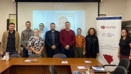
Globally, the frequency and intensity of natural disasters is increasing due to climate change. October 13 was International Day for Disaster Risk Reduction (DRR).
A new geological 3D model for planning of Czech part of the Erzgebirge railway tunnel has been added to the overview map on the web page 3D geological models .
CGS participates in Hystories – a European project focusing on hydrogen storage in porous geological structures, namely in depleted hydrocarbon fields and aquifers.
Project coordinator Vit Hladik presented the CO2-SPICER project at the international TCCS-11 conference (11th Trondheim Conference on CO2 Capture, Transport and Storage).
During March and April 2021, the CGS metadata team (Dana Čápová, Pavla Kramolišová and Olga Moravcová), supported by colleagues from GSI (James Trench and Trevor Alcorn) prepared sets of training videos.
The Czech Geological Survey has issued a press release reporting about implementation of the Czech-Norwegian project CO2– SPICER (CO2 Storage Pilot In a CarbonatE Reservoir).
The Bohemian Massif is a key area for understanding of the process of the Tibetan-Himalayan-type continental collision, and it is also one of the best-studied areas in the world.
An article explaining metamorphic microdiamond formation in the world was published in the prestigious journal Scientific Reports. The paper was authored by the CGS specialist Jana Kotková.
A new geological 3D model for planning of the Střešovice railway tunnel in Prague 6 (J. Franěk et al. 2020) has been added to the overview map on the web page 3D geological models .
The Czech Geological Survey has prepared a leaflet informing about main aims and activities of the CO2-SPICER project, in both Czech and English versions.
On 5 March 2021, the Czech Geological Survey organized the conference Czech-Norwegian Cooperation on CCS, focused on the CO2 capture and storage technology.
CGS is the main organizer of the online conference titled “Czech-Norwegian Cooperation on CCS”, which will be held on 5 March 2021, from 9 a.m. to 1 p.m.
In the overview map on the http://www.geology.cz/extranet-eng/science/earths-crust/3d page, a new conceptual 3D geological model of the Rožná uranium deposit (J.
CzechIndustry, the magazine for Czech industry, trade, transport, and construction, has published an interview with Zdeněk Venera, Director of the Czech Geological Survey (CGS), and Kryštof Verner, Principal Investigator for CGS development...
The Czech Geological Survey was granted the patent PV 2018-357, in force as of 31 December 2020, for processing graphite raw material.
Challenge Fund, within the Czech-UNDP Partnership (CUP) for Sustainable Development Goals between the Czech Development Agency and the United Nations Development Program has supported a project Methodology for the area assessment in terms of debris...
The web page 3D geological modeling on the Czech Geological Survey website has been extended.
English version of the web map application "Interesting geosites of the Czech Republic" currently presents a new layer depicting the Czech national geoparks. It includes an English description and links to English webpages of the geoparks as well.
The Czech Geological Survey published a 1:25,000 scale geological map of the northern part of James Ross Island, located east of the northernmost tip of the Antarctic Peninsula. This is the first geological map of this area.
Due to the global epidemiological situation was the traditional Esri UC held virtually during the days 13.-16.7.2020. More than 86,000 registered users had the possibility to attend cca 500 technical workshops and demonstrations of GIS usage.