Currently, the most socially significant engineering geological research of the Czech Geological Survey (CGS) mainly includes intensive long-term research into environmental geohazards on a regional and local scale, their documentation, geohazard classification, and the development of a slope deformation inventory for the professional and lay public. The geohazard research also includes the study of radon from the bedrock. Applied geological research is essential for the planning of strategic structures becuse they can be planned in a more effective and thus economically efficient manner, particularly in relation to the territory‘s geological structure or to the existence of various geohazards.
Geohazards
Definition of geohazards
Environmental geohazards are defined by the Act on Geological Work (Act No. 62/1988 Coll.), and the notification of their detection is regulated by a special Decree of the Ministry of Environment on planning, conducting and evaluating geological projects, on reporting geohazards, and on the procedure for estimating reserves of reserved deposits (Decree No. 369/2004). Natural conditions or processes in the rock environment, which may pose a significant natural risk to humans and their activities and which are listed in Annex 9 of the decree, are considered geohazards.
Slope movements and radon risk may be considered as some of the most serious geohazards that most often affect our lives. Slope deformations due to slope movements may pose an immediate threat to the public interest, particularly to the lives and health of people, their property, to existing or planned investments in critical infrastructure (product pipelines – crude oil and natural gas pipelines) or transportation infrastructure (railways, roads) and so forth. The radon risk from the bedrock directly influences the population‘s exposure to radiation. The significance of dealing with radon occurrence in the bedrock lies, among other things, in the fact that it is linked with interdisciplinary monitoring of radon concentrations in potable water and building materials.
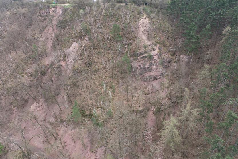
Aerial view of the upper part of the outcrops of Lower Devonian clastic sediments on Červený Hill with an active rockfall.
|
Author: Jiří Nečas
Slope movements
Urbanized landscapes and man-made structures are becoming more vulnerable to slope movements with the ongoing climate change and the current expansion of social and economic activities. In order to protect the landscape and society from damage, it is necessary to be well aware of the hazards.
Sufficient awareness of hazards resulting from slope movement processes will ultimately reduce costs borne by society for strategic planning and landscape development and also lead to improving the state‘s efficient management during the planning of major strategic as well as local infrastructure construction projects and to solving stability problems that already exist.
The origin and evolution of slope movements is determined by the complex interaction of extreme climatic situations, the territory’s geological structure, the geomorphology of the terrain, and human activities. Locally, the triggering mechanism usually involves extreme precipitation, intense snowmelt, mining and unsuitable building foundations.
Thorough studies on slope movements are conducted by the CGS in the Czech Republic as well as abroad.
Study of slope movements in the Czech Republic
Currently, the most important CGS activity involving the survey of slope movements in the Czech Republic is the unification and modernization of a single publicly accessible information portal, which provides modern and up-to-date information on all known slope deformations in the Czech Republic in the Inventory of Slope Deformations.
A unified central database of slope deformations for the entire Czech Republic, compiled based on standard and innovative approaches to assessing and understanding the spatial distribution, activity, movement mechanism and, primarily, the triggering mechanisms of slope processes, is necessary to substantially increase the awareness of state authorities, local governments and of the public.
Among other things, the research also includes the study of general criteria associated with the occurrence of landslides using critical evaluations aided by modern geographic information covering the entire territory of the Czech Republic, such as LIDAR – DMR 5G, satellite data, water availability in soil, 3D models of major landslides, and so forth.
Study of slope movements abroad
The CGS has long been involved in the study of slope movements abroad. An important topic involves slope movements in high mountain regions in connection with glaciers. The topic is not only important from a geological perspective, but it also has an environmental aspect in connection with the ongoing climate change, which manifests itself in high mountain regions particularly by gradual deglaciation with observable melting of glaciers. This is exposing areas that are sensitive to this geologically rapid change in conditions and that are highly susceptible to various types of slope movements, often of catastrophic proportions. The CGS is studying model cases in the Andes in Peru and in the Caucasus in Georgia.
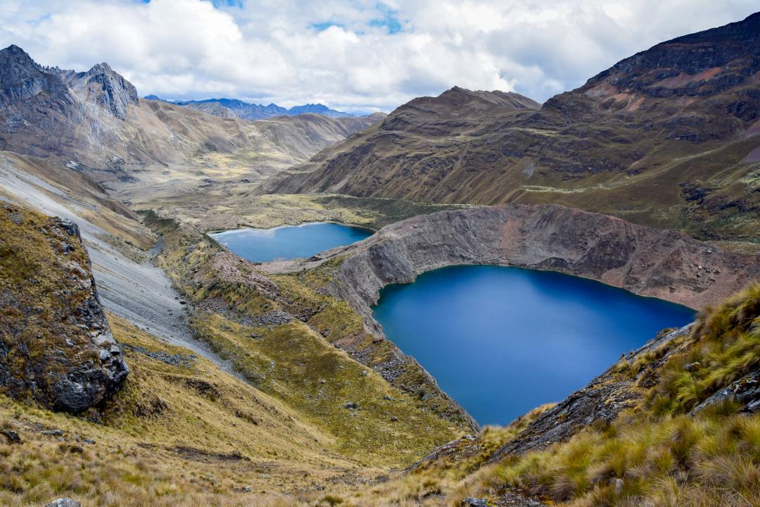
Study of the moraine dam stability of glacial lakes, Peru


The collapse of glacier sections or rock and soil mass into a glacial lake generates a large wave causing an outburst through a moraine dam and triggering a debris flow of catastrophic proportions, with devastating effects of up to tens of kilometres from its place of origin. An example is the outburst from Lake Palcacocha in the Cordillera Blanca in 1941, when part of the city of Huaráz was struck by a debris flow that killed several thousand inhabitants. Lake Palcacocha is a model study area where the CGS primarily examines the stability of moraine dam slopes, including stability calculations, in cooperation with the Institute of Rock Structure and Mechanics of the Czech Academy of Sciences.
Study of the stability of high rock slopes above glacial lakes, Peru
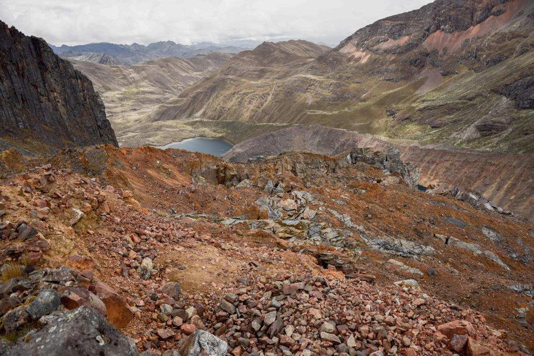
High rock slopes and walls, which are unstable from a long-term perspective, are exposed as glaciers retreat. Large rockfalls from the slopes have rather been isolated thus far. It appears that the falls do not occur immediately after a glacier, which provided long-term slope support, retreats but only after a certain delay. Therefore, more frequent rockfall-type slope movements can be expected in the future. If they occur above lakes, they can trigger catastrophic debris flows, as in the case of Lake Palcacocha. Examples of a major rockfall that was studied in detail by the CGS in collaboration with the Institute of Rock Structure and Mechanics of the Czech Academy of Sciences were the Safuna Alta and Safuna Baja sites in the Cordillera Blanca in Peru. Here, a massive rockfall occurred in 2002 causing masses of rock to collapse as far as Lake Safuna Alta. Fortunately, the moraine dam survived the event and did not burst. The water wave triggered by the rockfall into the lake spilled over the dam into the lower Lake Safuna Baja causing flooding and erosion downstream.
Georgia
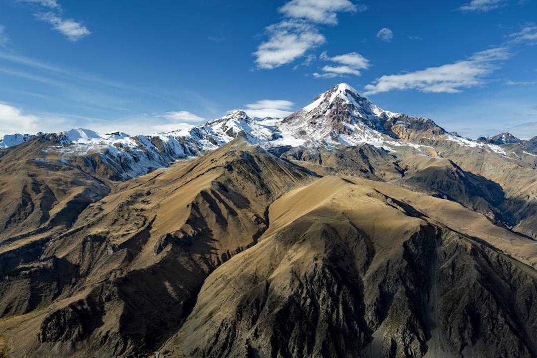
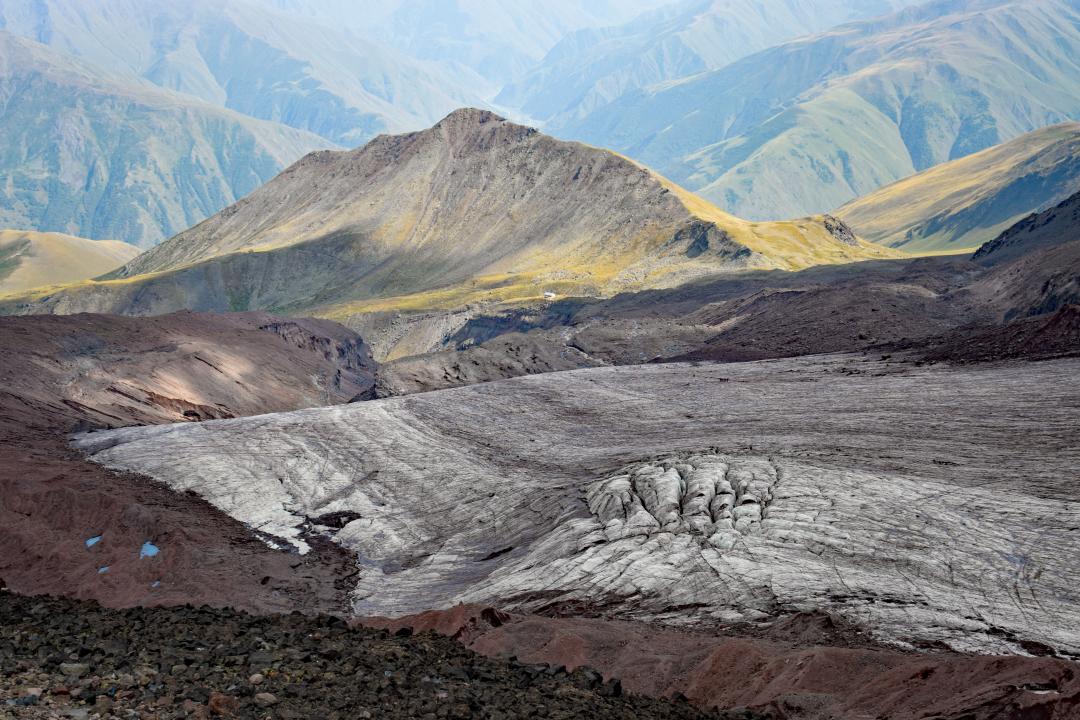
The Greater Caucasus is a major mountain range forming Georgia‘s northern border with Russia. Here, the CGS is studying slope stability issues in the Kazbegi Municipality, dominated by Mount Kazbek which is over 5,000 metre high. The area has experienced a rich history of slope movements. The most destructive events are massive debris flows, which repeatedly surge down Mount Kazbek and which have been documented for more than 200 years. Due to the conical shape of the mountain (which is genetically a volcano), the debris flows surge down glacial valleys in all directions, even beyond Georgia into Russia, and their length ranges from kilometres to tens of kilometres. Debris flows are often triggered by the fall of a glacier onto unconsolidated glacial sediments in its vicinity. Since some parts of glaciers become unstable due to gradual melting, catastrophic slope movements can be expected to occur in the future.
The last such debris flow occurred in the Darial Gorge east of the Kazbek peak on Georgia‘s northern border with Russia in 2014, when a section of a glacier collapsed producing a debris flow and related natural events that caused ten deaths and serious material damage. The occurrence of debris flows was also documented in other areas of the Kazbek massif, such as the Kolka, Abano, Mna and Gergeti glacier valleys.
The CGS is mapping and evaluating the area in order to develop a conceptual engineering geological model. The aim is to generate spatial and, possibly, temporal predictions of catastrophic slope movements. The existing geohazards can be reduced significantly by suitable use of the landscape, thus eliminating loss of human life as well as material damage.
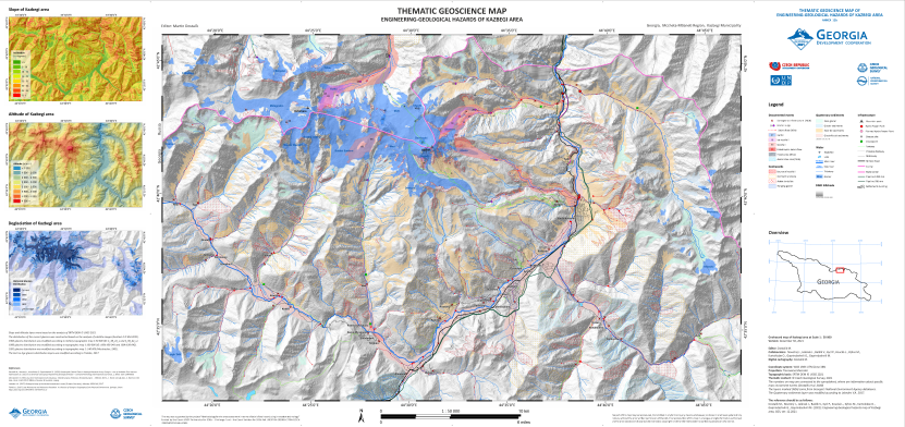
Map of engineering-geological hazards in the Kazbegi Municipality at 1:50,000 scale, which is one of the outputs of the "Georgia 2021" development project.
Radon risk
More than two-thirds of the Czech Republic‘s bedrock is composed of metamorphosed and igneous rocks with elevated concentrations of uranium and, subsequently, also of radon. This shows that increased attention must be given to radon, which originates from the bedrock and seeps into objects. In addition to uranium (U), potassium (K) and thorium (Th) contribute to radiation from natural sources as well.
The radioactive decay of radon produces daughter isotopes of a metallic nature, which can increase the incidence of lung cancer through internal exposure by adhering to lung tissue. The CGS is tasked with searching for rock types with elevated concentrations of radon that can seep into structures built on top of them and adversely affect the health of residents due to long-term exposure.
Long-term radon monitoring in the Czech Republic has been conducted and coordinated by the State Office for Nuclear Safety under the National Radon Action Plan (RANAP). The multidisciplinary and preventive research on radon risk from the bedrock includes areas such as radon in potable water or building materials. The bedrock is thus the primary source of radon in buildings.
CGS research activities focus on monitoring radon concentration and dose rate values in local lithological rock types with anticipated elevated values of these magnitudes. The occurrence of the rocks may depend on structural conditions and also on contacts with rocks with significantly different radon risk categories. The research outputs serve as a basis for updating maps and, in the case of confirmed elevated radon risk, are published in the Comprehensive Radon Information application on the CGS Map Server.
Research for planning strategic structures
One of the state‘s key tasks is to complete the construction of missing transportation infrastructure, or generally to fund strategic structures of national importance. Safe and functional transport connections and construction of critical infrastructure are one of the basic conditions for the continued development of the Czech Republic and its regions.
The building of any structure must go hand in hand with an understanding of the historical-geological development of the territory and all its processes, which have led to the current status of the rock environment. Therefore, CGS research activities involving the planning of strategic structures focus on identifying geotechnical, geological and hydrogeological safety risks and on optimizing proposed engineering geological surveys for planned structures of national importance.
The benefits of the activities are mainly economic. More efficient planning of follow-up geological-exploration work should save a considerable amount of financial resources. Additional financial savings may be expected during the actual building of the structures, because a comprehensive interpretation of various input data should minimize potential increases in costs and delays in construction due to accidents caused by adverse geological conditions or minimized safety risks.
The main research outputs are 3D visualizations of engineering geological models including their descriptions, which, in addition to optimizing proposed engineering geological field surveys for planned structures of national importance, should also aid in proposing optimal technologies for the construction of the actual structures.