Regional geological mapping of the Czech Republic at 1:25,000 scale is one of the priorities of the Czech Geological Survey (CGS) and an integral part of comprehensive geoscientific studies that help evaluate many aspects of environmental quality. Educating society in these geological disciplines is of great importance for a wide range of practical human activities and may, for instance, significantly minimize impacts of natural events.
Geological mapping
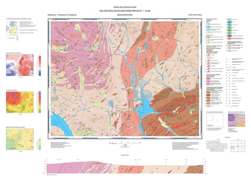
Regional Geological Map of the Czech Republic 1:25,000, 32-231 Horní Planá.
|
Author: J. Pertoldová, R. Nahodilová
Information provided by geological maps
A geological map is a specialized depiction of the geological structure of the Earth‘s surface on a topographic map of a given scale. A geological map shows the type, shape and age of rock bodies, including their interrelationships, the orientation of faults, and the nature and extent of Quaternary sedimentary cover and weathered rocks. In addition, a geological map displays active and abandoned quarries, sand pits, loam pits, mine workings, significant springs, important boreholes, landslide areas as well as waste dumps and interesting geosites. The map is also used to assess hydrogeological conditions, the occurrence of minerals, the overall stability of construction areas, and environmental aspects. It includes a legend with information on the age and stratigraphic affiliation of rocks, a geological cross-section with an interpretation of the orientation of rock bodies beneath the Earth‘s surface, and a lithostratigraphic chart showing the relationship between sedimentary rocks and their age. Systematic creative and highly interpretative work by a team of experts is required in order to compile a geological map. The results of geological mapping, presented in graphical and written form, serve as a basis for subsequent geological research and land-use planning as well as for educating professionals and the public.
Geological mapping as a fundamental element of geoscientific research with implications for social development
In order for society to effectively guard against and minimize consequences of catastrophic natural phenomena, it is important to cooperate with geologists and other specialists, whose recommendations should willingly be taken into account particularly by public authorities at all levels. Modern methods of processing, storing and providing geoscientific data increase their credibility, returns on investments, and contribute decisively to their use (see Geological Information System). Geological maps are primarily used by public authorities for land-use planning, to identify potential geohazards, to assess the significance of mineral deposits and groundwater reserves, and they also serve as basic sources of information for environmental and engineering applications. In addition to clarifying the geological evolution of the Czech Republic‘s territory, geological research also significantly helps to generally assess the geological and geochemical hazards that influence the ecosystem (e.g., landslides, toxic element anomalies, flood sediments, groundwater and surface water contamination). Optimal results can only be achieved through close collaboration between geologists, biologists, ecologists, chemists and other professions.
A light rhyolite dyke of Cambrian age piercing Neoproterozoic shale, siltstone and greywacke above a floodplain in the Berounka valley near Račice. The dyke, which belongs to the volcanic units of the Křivoklát-Rokycany belt, penetrated along a north-south oriented fault, the manifestation of which is visible at its western contact. Behind the large house at the dyke‘s base is a continuously flowing spring with precipitated calcareous sinter. The plateau above the rocky defile corresponds to a fluvial terrace of the Berounka River of Lower Pleistocene age, where a part of the village of Sýkořice is located. Above the terrace, a hill rises along the dyke, where the dyke widens and where several now abandoned quarries are located. The yellowish to reddish rhyolite with conspicuous grey phenocrysts of quartz and white feldspar occurring in the quarries was a sought-after building material and used in many of the buildings in Sýkořice and villages in the wider surroundings.
|
Author: Vladimír Žáček, 2023
Examples of current CGS mapping projects in the Czech Republic and abroad
SÚRAO (Radioactive Waste Repository Authority)
Geological and hydrogeological mapping at 1:25,000 scale is being conducted at four selected sites within the scope of the Horizontal Cooperation project. Upon approval of a permit of an exploration area for special interventions into the Earth's crust, mapping will continue at 1:10,000 scale as well. The output will include 15 geological maps at 1:25,000 scale and four maps at 1:10,000 scale, which will serve as one of the bases for selecting a final site suitable for constructing an underground radioactive waste repository. After the maps and other technical work (boreholes, geophysics) are completed, 3D geological, hydrogeological and geotechnical models of the area will be produced based on the map data.
Šumava National Park and Protected Landscape Area
A total of 31 geological maps at 1:25,000 scale with explanatory notes were compiled for the Šumava and Pošumava regions in 1986–2023. Work is currently underway on a monograph of the Šumava Mts, which will include a 1:75,000 scale map covering an area exceeding 2,500 km2. All collected data are stored in a database of geological documentation points and linked to the database of geochemical analyses and important geological localities. These more than 11,000 records represent the main set of scientific data for the monograph. The forthcoming monograph will include a compilation of the above-mentioned geological maps, their explanatory notes, data from the databases, and a review of the geological structure covered by older geological maps, all supplemented with updated field data.
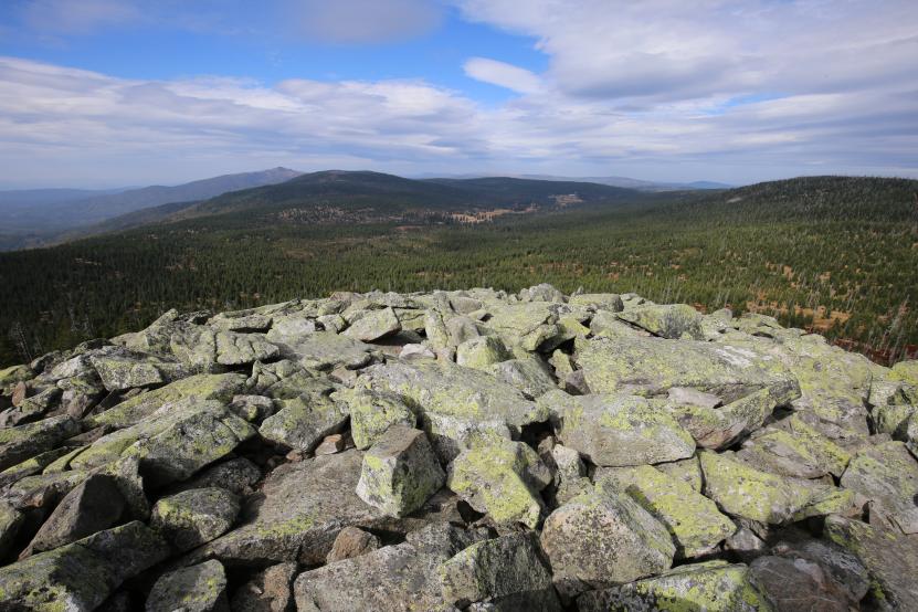
Geology knows no boundaries – the Czech-Bavarian border in the central Šumava Mts. A disintegrated outcrop of light medium-grained granite with muscovite forms a boulder field on the summit of Luzný Mountain (1,373 m ASL). Velká Mokrůvka Mountain (1,370 m ASL) is located to the right in the background, the forestless Luzenské Valley with a lodge on Březník Mountain in the centre, Blatný vrch Mountain (1,367 m ASL) to the left of the valley, and Velký Roklan Mountain, the second highest peak of the Šumava Mts with an altitude of 1,453 m, in the background.
|
Author: Vladimír Žáček, 2023
Brno Agglomeration and Moravian Karst Protected Landscape Area
The geological mapping of the Brno agglomeration, the aim of which was a comprehensive evaluation of the geological structure based on archived documents and new detailed field mapping, is now of irreplaceable importance for land-use planning. The project also included a characterization of the soil cover, of the area‘s engineering geology and hydrogeological potential, and an assessment of organic and inorganic soil contamination. The maps and explanatory notes were published.
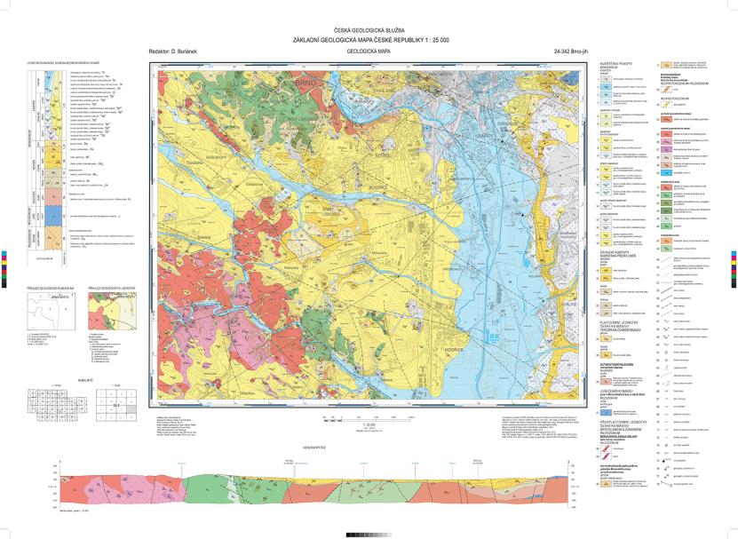
Regional Geological Map of the Czech Republic 1:25,000, 24-342 Brno-jih.
|
Author: David Buriánek
Ethiopia
Geoscience maps of four regions with a total area of roughly 20,000 km2 are being compiled during ongoing foreign development cooperation projects in Ethiopia,. Geological, hydrogeological and soil maps at 1:100,000 scale include extensive explanatory notes. A national geological and hydrogeological map of the entire territory of Ethiopia at 1:1,000,000 scale is being produced as well. The scientific findings are also continuously published in reputable international journals.
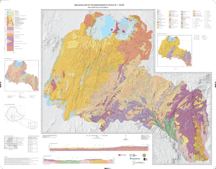
Geological map 1:100,000, Sidama Region, Ethiopia.
|
Author: Kryštof Verner, Leta Megerssa