The animations of the Czech Geological Survey depict the geological evolution of selected sites and geological processes in a visual and engaging way. They are published on the CGS YouTube channel. Most of the animations have English subtitles, thereby appealing to people interested in geology throughout the world. The animations are based on intensive geological research conducted by our specialists in a given area.
Animations
Geological processes and the formation of significant sites
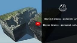
The Blanice Graben is an important fault system, partly occurring as a graben running from the eastern surroundings of Prague through Tábor, České Budějovice all the way to Austria. The animation depicts its formation.

Calderas are giant volcanic craters that form when all or a substantial part of a magma chamber is emptied at once during a single eruption. The
animation shows caldera eruptions.

The animation shows how weathering and erosion during the tertiary and quaternary periods carved out rock towers and other formations from the sandy sediments.
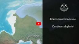
During the lower Quaternary, specifically the Pleistocene epoch beginning roughly 2.5 million years ago and ending as late as 10,000 years ago, the area of the Czech Republic was sandwiched between a northern European continental glacier, whose southern edges reached the Czech Republic‘s territory twice.
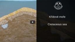
A rugged terrain was suddenly flooded by the Cretaceous sea. Some protruding rocks formed islands, at the foot of which conglomerates containing many fossils formed, which are typical for shallow and warm seas.

The highest mountain of the Žďárské vrchy Hills was originally prolonged mountain ridge, which gradually disintegrated during the glacial and interglacial periodsto the current shape of nine separated rock blocks. Gneiss rocksare a proof of anenormous power of erosion acting for along time.
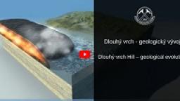
The created animation clarifies the geological evolution of the area of Dlouhý vrch Hill, including the formation of hyaloclastite breccia, that lines lava flows, and the formation of quartzite beneath the volcanic rocks. Quartzite is the product of sandstone silicification, resulting from the mobilization of quartz in hot alkaline solutions.

The formation of continents during the geological development of the Earth. The red dot indicates how the territory of the current Czech Republic moved.
A volcanic eruption is driven mainly by gases dissolved in magma. As the magma rises to the surface, the pressure decreases and gas bubbles begin to be released from the magma. As the number and size of bubbles grow, they begin breaking the magma into smaller particles, and the escaping gas ejects volcanic debris from the volcano's throat onto the surface.

A growing volcano produces distinctive topographic features. In addition, volcanic slopes are often formed from incoherent rocks, which may be set in motion by earthquakes, other volcanic eruptions or heavy rains. Such massive slides of volcanic material are referred to as lahars.
If rising magma encounters a layer of rocks saturated with water, the temperature contrast causes the water to flash to steam. An explosion occurs, ripping out rocks above the area of the explosion, and a funnel-shaped crater is formed. It is partly filled with breccia, but a circular lake may form in the upper part. This is how a volcanic crater referred to as a maar is formed.
When lava flows onto wet sediments (for instance, on a lakeshore or in a riverbed), the water enclosed beneath the lava begins to boil. The produced steam then explodes through the still liquid lava. This process forms rootless vents. They are "rootless" due to not having their own magma conduit.

Ještěd Mountain, a landscape landmark towering above Liberec, is the result of a complex geological evolution lasting 600 million years. Granites intruded the oldest Proterozoic marine sediments accreting into an accretionary wedge.
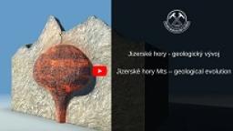
The Jizerské hory Mts consist of a composite granite massif. About 325 million years ago, the Tanvald Granite intruded into the surrounding folded and metamorphic rocks. After it cooled down, the Liberec Granite intruded into its centre. The current morphology of the Jizerské hory Mts was gradually shaped by erosion of the resistant granites.
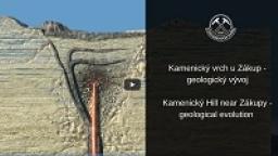
Kamenický Hill near Zákupy represents a specific type of volcanic formation, which is referred to as a diatreme. It is a funnel, above which a circular crater, a maar, was located. Kamenický Hill belongs to the so-called Lusatian Volcanic Field.
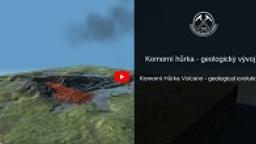
The magmatic origin of volcanoes was proven and the hypothesis of volcanoes fed by burning coal seams refuted. Komorní hůrka thus played an important role in the history of Earth science and in understanding the geological structure and processes.
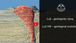
Luž is not only the highest peak of the Lužické hory Mts, but it also has the most varied volcanic history in this area. However, two domes were probably formed during Luže Hill’s history.
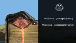
Although Milešovka Hill, the highest peak of the České středohoří Mts, is of volcanic origin, it is not a true volcano as illustrated by the animation.

The depression of the Carpathian Foredeep was formed during the Carpathian orogeny in the Mesozoic and Tertiary. In the territory of today's Slovakia, layers of sediments formed merging into mountain ranges that slowly moved in the form of large nappes onto the solid Bohemian Massif.
An ocean basin several kilometers deep was formed after the continental crust ruptured. As the continental plates gradually receded from each other, the area between them deepened, subsided and began to fill with sediments.
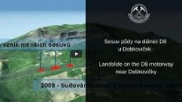
In June 2013, a slope slid onto the D8 motorway under construction. CGS staff created an animation to better illustrate the entire situation, the geological processes that gradually formed a landslide-prone slope, and the sequence of individual events leading to the landslide.
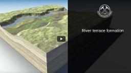
Sand and gravel are essential raw materials for construction. These unconsolidated sediments were deposited by rivers. In Europe, they often occur as river terraces comprising gravel, which form due to alternating phases of gravel deposition and river incision.

Šemnice Rock, which rises above the Ohře River near Karlovy Vary, is one of the few phonolite outcrops in the Doupovské hory Mts. The vent of this volcano formed along a marginal fault of the Ohře Rift. Initially, a massive basaltic lava flow occurred. Subsequently, viscous phonolite lava was forced to the surface, solidifying in the form of a volcanic spine.

The second most common volcanic rock in the Czech Republic after alkaline basaltic rocks is phonolite. However, most phonolites did not form from flowing lava but solidified at shallow depths beneath the surface in the form of sills or laccoliths. This is also the case of Tachov Hill located near Doksy, whose formation is depicted in the animation.
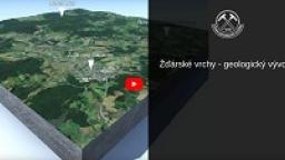
The geological development of the Žďárské vrchy Hills can be described as a sort of abstract fairy tale about origin and development of selected rocks. The shape of the local landscape was actually completed relatively short time ago – during the glacial and interglacial periods and in the course of the last centuries.
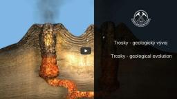
The characteristic silhouette of the rock formation known as Trosky is the result of volcanic activity, which occurred in the Bohemian Paradise 19–16 million years ago.
his unique geological evolution cycle, which occurred in the Middle Devonian and Carboniferous, is recorded precisely in the rocks in the Czech Republic up to depths of 80 km beneath the then surface.

The Velké Dářko Pond is the biggest water reservoir by far; at the same time, it is a source of the Sázava River. The pond surroundings are bordered by wetlands with occurrence of protected plant and animal species.
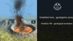
The formation of Vinařice Hill was influenced by various types of volcanic activity, making it a valuable locality revealing various volcanic deposits.
Formation of volcanoes
The Blanice Graben is an important fault system, partly occurring as a graben running from the eastern surroundings of Prague through Tábor, České Budějovice all the way to Austria. The animation depicts its formation.
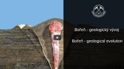
The characteristic rock formation in the valley of the Bílina River at the western edge of the České středohoří Mts is of volcanic origin. Bořeň’s current shape is the result of erosion, which exposed the phonolite stock as the surrounding softer disintegrated rocks eroded.
Calderas are giant volcanic craters that form when all or a substantial part of a magma chamber is emptied at once during a single eruption. The
animation shows caldera eruptions.
The created animation clarifies the geological evolution of the area of Dlouhý vrch Hill, including the formation of hyaloclastite breccia, that lines lava flows, and the formation of quartzite beneath the volcanic rocks. Quartzite is the product of sandstone silicification, resulting from the mobilization of quartz in hot alkaline solutions.
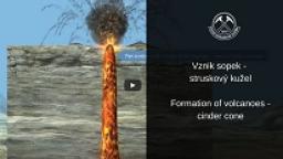
A volcanic eruption is driven mainly by gases dissolved in magma. As the magma rises to the surface, the pressure decreases and gas bubbles begin to be released from the magma. As the number and size of bubbles grow, they begin breaking the magma into smaller particles, and the escaping gas ejects volcanic debris from the volcano's throat onto the surface.
A growing volcano produces distinctive topographic features. In addition, volcanic slopes are often formed from incoherent rocks, which may be set in motion by earthquakes, other volcanic eruptions or heavy rains. Such massive slides of volcanic material are referred to as lahars.
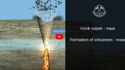
If rising magma encounters a layer of rocks saturated with water, the temperature contrast causes the water to flash to steam. An explosion occurs, ripping out rocks above the area of the explosion, and a funnel-shaped crater is formed. It is partly filled with breccia, but a circular lake may form in the upper part. This is how a volcanic crater referred to as a maar is formed.
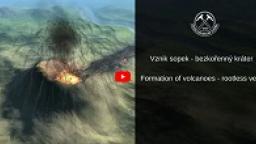
When lava flows onto wet sediments (for instance, on a lakeshore or in a riverbed), the water enclosed beneath the lava begins to boil. The produced steam then explodes through the still liquid lava. This process forms rootless vents. They are "rootless" due to not having their own magma conduit.
Kamenický Hill near Zákupy represents a specific type of volcanic formation, which is referred to as a diatreme. It is a funnel, above which a circular crater, a maar, was located. Kamenický Hill belongs to the so-called Lusatian Volcanic Field.
The magmatic origin of volcanoes was proven and the hypothesis of volcanoes fed by burning coal seams refuted. Komorní hůrka thus played an important role in the history of Earth science and in understanding the geological structure and processes.
Luž is not only the highest peak of the Lužické hory Mts, but it also has the most varied volcanic history in this area. However, two domes were probably formed during Luže Hill’s history.
Although Milešovka Hill, the highest peak of the České středohoří Mts, is of volcanic origin, it is not a true volcano as illustrated by the animation.
Šemnice Rock, which rises above the Ohře River near Karlovy Vary, is one of the few phonolite outcrops in the Doupovské hory Mts. The vent of this volcano formed along a marginal fault of the Ohře Rift. Initially, a massive basaltic lava flow occurred. Subsequently, viscous phonolite lava was forced to the surface, solidifying in the form of a volcanic spine.
The characteristic silhouette of the rock formation known as Trosky is the result of volcanic activity, which occurred in the Bohemian Paradise 19–16 million years ago.
The formation of Vinařice Hill was influenced by various types of volcanic activity, making it a valuable locality revealing various volcanic deposits.

Couple of maar volcanoes has been recently discovered in western Bohemia, near to village Polná. The activity of the first crater, known as Ztracený rybník, terminated with maar-forming explosion. The second crater, known as Bažina experienced more complex evolution.